John Muir Trail
"Climb the mountains and get their good tidings. Nature's peace will flow into you as sunshine flows into trees. The winds will blow their own freshness into you, and the storms their energy, while cares will fall off like autumn leaves."
-John Muir
In the summer of 2006 I hiked 240 miles through the High Sierras in California in a fundraising effort for the American Cancer Society's Camp Sunrise, a summer camp for children living with pediatric cancer. The hike took me along the full length of the scenic John Muir Trail, through three separate national parks (Yosemite, Kings Canyon and Sequoia), and to the summit of Mt. Whitney, the highest peak in the continental United States. Thanks to many generous donations, I was able to raise over $1000 for the children of Camp Sunrise.
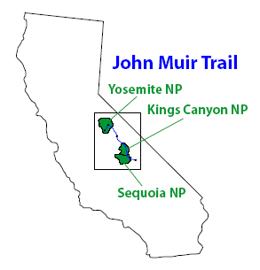
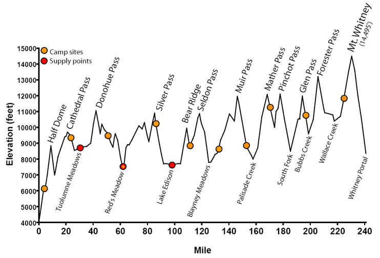
The 211-mile John Muir Trail (JMT) runs along the High Sierras in California and passes through what many backpackers say is the finest mountain scenery in the United States. This is a land of 13,000' and 14,000' peaks (including the 14,495' Mt. Whitney), of lakes in the thousands, and of canyons and granite cliffs. It's also a land blessed with the mildest, sunniest climate of any major mountain range in the world.
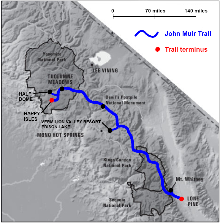
The JMT runs through 3 National Parks: Yosemite (Official NPS Page), Kings Canyon and Sequoia (Official NPS Page). When not within a National Park, it runs through Forest Service (Official Inyo National Forest Page) land, including the John Muir and Ansel Adams Wilderness areas. The trail also passes through the Devils Postpile National Monument near Red's meadow. Because the JMT ends at the highest point in the lower 48 states, after "completing" the trail I still had to hike another 11 miles and 6000 ft. down to Whitney Portal and Lone Pine. A detailed map and elevation profile of the hike are shown below.
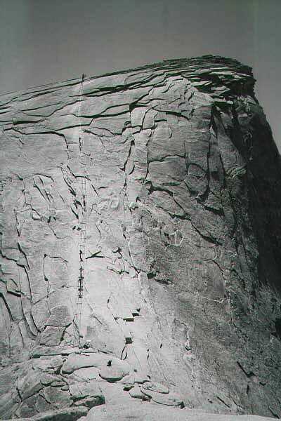
The 2006 Hike for Cancer event included a side trip up Half Dome which is located within Yosemite, as well as a resupplying side trip to the Vermilion Valley Resort at Edison Lake.
By averaging almost a marathon worth of walking per day, I completed this 240-mile hike in 11 days.
some of this information was taken from the Pacific Crest Trail Association
Detail map of the area in California shown above.
Here is how I ended up hiking the JMT...
Day 0 (August 3, 2006) - 4.7 miles
Happy Isles to Little Yosemite ValleyDay 1 - 18.5 miles
Little Yosemite Valley to Cathedral Lake Trail
(including side trip up Half Dome)Day 2 - 22.0 miles
Cathedral Lake Trail to Rush CreekDay 3 - 17.5 miles
Rush Creek to Red's MeadowDay 4 - 23.2 miles
Red's Meadow to Silver Pass LakeDay 5 - 25.1 miles
Silver Pass Lake to Bear Creek Trail
(including resupply trip to VVR)Day 6 - 20.9 miles
Bear Creek Trail to Goddard Canyon BridgeDay 7 - 21.6 miles
Goddard Canyon Bridge to Bishop Pass TrailDay 8 - 22.7 miles
Bishop Pass Trail to Lake MarjorieDay 9 - 20.2 miles
Lake Marjorie to Kearsarge Pass TrailDay 10 - 27.8 miles
Kearsarge Pass Trail to Guitar LakeDay 11 - 16.7 miles
Guitar Lake to Whitney Portal
(including summit of Mt. Whitney)
Happy Isles (the starting point) is over 4,000' above sea level. In the 24 hours on the trail I gained more than mile in elevation! Luckily I had over a week to get acclimated to the high altitude before reaching the monster peaks towards Mt. Whitney.